


AirspaceConverter details
Why this software?
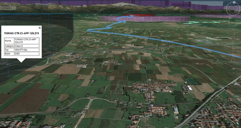
Airspace represented in 3D in Google Earth can help to visualize and better understand the airspace structure. Not only, having the planned route or track of a flight (as GPX file), displayed as well in Google Earth will make easy to check for airspace crossed or to be avoided.
This software can also be useful for maintainers of OpenAir airspace and SeeYou waypoints files, not only to visualize airspace and waypoints but also to verify
the syntax of OpenAir or SeeYou lines entered.
Duplicate consecutive points will be ignored, the converter will warn about them while reading OpenAir files. This will also detect the special case of an unnecessary point
repeating the end of the arc defined on the previous line.
For the "landable" waypoints in the CUP files an estimation of the runway perimeter is drawn on the earth surface, in order to do that not only the position is used but also the runway
orientation and length. This is particularly useful to verify that the position of the airfield in the CUP file matches exactly the runway in Google Earth.
In software like LK8000 the airfield position is considered as the exact center of the runway,
orientation and length are used to assist for landing with an HSI and glide slope indications; thus the correctness of: position, orientation and length becomes quite important.
openAIP provides a free, worldwide and updated airspace and waypoint repository but in his own format,
while many devices and software support OpenAir airspace files. This software can convert: openAIP airspace to OpenAir and openAIP waypoints to
SeeYou; so making openAIP data available to many portable devices.
AirspaceConverter can be used also to merge together several airspace or waypoint files (openAIP repeated airspaces will be automatically removed) and filter the result on a
specific range of latitudes and longitudes.
Converting openAIP files to OpenAir has also the advantage to reduce significantly the size of the total airspace database used on a portable device.
For example LK8000 recently supports also the openAIP format (feature that I implemented) but it is not always possible to load bigger openAIP files on older PNA devices,
while the same files converted in OpenAir yes.
There are also cases where the "official" airspace files are available only in KML format like
the Austrian airspace from Austrocontrol,
also in this case is possible to convert it to OpenAir.
In case is required to import long lists of points (like state borders) from KML LineString tracks: just use the option -t and the tracks found will be closed and treated as unknown airspace.
Then it will be possible to adapt the airspace definitions manually in the so converted OpenAir file.
KML format
The Keyhole Markup Language, used by Google Earth
is probably a good format to define models of buildings but it is not exactly practical to define airspace.
This because it not possible, at least from my understanding, to define in the same 3D object points at altitudes with different references:
it is the typical case of an airspace with AGL floor and AMSL ceiling.
One possible solution is to translate, where necessary all the altitudes to the same reference but to do that we need the know the altitude of the terrain at every location.
Another important limitation of KML is that surfaces which follow the terrain are possible only at terrain altitude.
So please, be advised that, what you will see in Google Earth will not exactly match how airspace definitions are really intended.
Example files
Here there are some files produced and/or verified with AirspaceConverter:
- Latest, updated, already converted openAIP worldwide airspace (OpenAir, GoogleEarth)
- Latest, updated, Italian airspace and airfields (OpenAir, SeeYou, GoogleEarth)
- Older Austrian airspace in OpenAir
LK8000 terrain raster map files
AirspaceConverter uses the same terrain raster maps (.DEM) of LK8000 to get the altitude of the terrain
and so to convert altitudes from AGL to AMSL.
In case the loaded terrain maps are overlapping, the one with the best resolution will be automatically used.
On the LK8000 website there is a wide
terrain raster map collection.
The part of this program reading and using the terrain maps has been derived and adapted from LK8000 project.
To know more about LK8000 open source project: www.lk8000.it
The source repository of LK8000 is available here: github.com/LK8000/LK8000
Command line version
The command line version works taking several arguments, for example:
airspaceconverter -q 1013 -a 35 -i inputFileOpenAir.txt -i inputFileOpenAIP.aip -w waypoints.cup -m terrainMap.dem -o outputFile.kmz
Main options:
-q: optional, specify the QNH in hPa used to calculate height of flight levels-a: optional, specify a default terrain altitude in meters to calculate AGL heights of points not covered by loaded terrain map(s)-i: multiple, input airspace file(s) can be OpenAir (.txt), openAIP (.aip) or Google Earth (.kmz, .kml)-w: multiple, input waypoint file(s) in the SeeYou CUP format (.cup), openAIP (.aip) or LittleNavMap (.csv)-m: optional, multiple, terrain map file(s) (.dem) used to lookup terrain height-o: optional, output file .kmz (Google Earth), .txt (OpenAir), .mp (Polish), .img (Garmin) if not specified will be used the name of first input file as KMZ-l: optional, set filter limits in latitude and longitude for the output, followed by the 4 limit values: northLat, southLat, westLon, eastLon where the limits are comma separated, expressed in degrees, without spaces, negative for west longitudes and south latitudes-p: optional, when writing in OpenAir avoid to use arcs and circles but only points (DP)-s: optional, when writing in OpenAir use coordinates always with minutes and seconds (DD:MM:SS)-d: optional, when writing in OpenAir use coordinates always with decimal minutes (DD:MM.MMM)-v: print version number-h: print short guide
At least one input airspace or waypoint file must be present.
Warning: any already existing output file will be overwritten.
Windows MFC user interface
Also the Windows MFC user interface relies on the same code of the library recompiled under Windows.
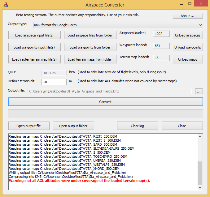
How to use it
- Choose the desired output format.
- If needed, specify the QNH to be used for calculating the height of flight levels, this must be done before reading airspace files.
- Specify a default terrain altitude to be used for the points not under terrain raster map coverage.
- Select as input multiple OpenAir (.txt), openAIP (.aip) or Google Earth (.kmz, .kml) files or the folder containing them.
- And/or select one or multiple waypoints files (.cup) or the folder containing them.
- Optionally it is possible to load multiple raster map files (.dem) with the terrain altitude.
- Optionally configure the latitude and longitude ranges for filtering the output.
- If converting to OpenAir choose if to output only points and the desired coordinates format.
- Press the button convert, the program will ask the name of the output file and the conversion process will then start.
- Verify if the output is correct and report any problem found.
Qt user interface
In order to be portable, the graphical interface has been written also in Qt and it can be compiled under Linux, macOS, and Windows.
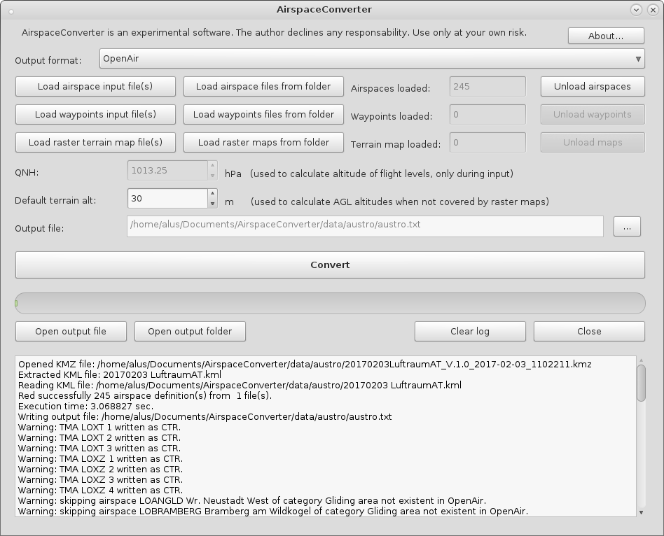
The Qt user interface is available in the Linux and macOS variants.
< AirspaceConverter Index | Download AirspaceConverter >