


Description of the application
This is a free, experimental and even fully open source software.
How it works
After the installation you will have a new icon in the menu, to start the program. Once started, the program will display the main menu where the user can select a flight plan then, starting the navigation, the program will process data from the integrated GPS receiver. The HSI will give visual indications to the next way point until the final destination is reached.
Disclaimer
This software is open source and free: it comes without any warranty. This is an experimental project. During a flight this program must not be used as the only navigation system.
HSI?
HSI stands for: Horizontal Situation Indicator, it is a very intuitive way to represent our position, direction and altitude respect what we planned in our route. To learn more about HSI:
What it does
- Guides you to fly precisely the route you already planned
- Shows an HSI to indicate how you are following the planned route
- Shows the direction you should head to follow your route
- Shows if you are on track and if not how much you are out from the planned route
- Shows an altitude bar indicating an estimation of the altitude you are flying respect the altitude planned in the route
- Shows all relevant information received from the GPS
- Estimates the remaining time to reach the next waypoint
- Estimates the arrival time to the final destination
- Tracks your flight
What it does not
- Just asks you where you want to land
- Plans a route for you
- Shows a moving map
- Warns you about prohibited or restricted airspace you must avoid
Main menu
The program just started will display its main menu, that is formed by buttons. When a button is disabled the text inside is displayed in italics. Those are buttons currently available:
Load flight plan
Allows to select and load the desired flight plan between the GPX files present in the Routes folder. If there aren't GPX files in the Routes folder this button will be not active. If pressed when a route is already loaded, the loaded route will be automatically unloaded when loading a new one.
Start navigation
Active only if a flight plan has been loaded and the navigation has been not yet started. Instructs the HSI to start to give indications to reach the next waypoint. When pressed the HSI screen is than displayed.
Reverse flight plan
Active only if a flight plan has been loaded. Allows to reverse the current flight plan. After reversing the navigation has to be restarted with the previous button.
Unload flight plan
Active only if a flight plan has been loaded. It unloads the current loaded route.
Show HSI
Shows the HSI screen, where more or less information’s will be displayed depending if a route has been loaded and if it has been started. A single touch anywhere in the HSI screen brings back the application to the main menu.
Start Track Recorder - Stop Track Recorder
Pressing start a new track file is created (in the Tracks folder) and the application will start to record in it. Pressing stop the application will stop recording and the track file will be closed.
Pause Track Recorder - Resume Track Recorder
Active only if the track recorder has been started. Without closing the track file, allows to suspend and resume the registration of the current track.
EXIT
Takes care of releasing all the used memory and terminate the application. If the application is installed as normal distribution, together with the TomTom software this button will bring back to the original TomTom navigation software. Otherwise if the application is installed as standalone distribution this button after terminating the application will switch off the TomTom device.
The HSI screen
Here a photo of my TomTom One XL running AirNavigator with some example data on the screen. All the data displayed as numbers should be rendered in a more intuitive way such as bars and gauges in the future versions.
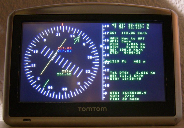
On the left side, Horizontal Situation Indicator:
- In white the compass rose
- In red the indicator of current true heading
- In green the course indicator to the next way point
- In yellow the course deviation indicator (XTD), displayed also in meters
In the center, the altitude scale:
- Every marker represents 50 Ft
- The numbers on the scale represent hundreds of Ft
- The white (red if out of scale) arrow on the left points the route altitude
- The green arrow on the right (center of the scale) points the current altitude
Right side:
- Latitude expressed in degrees, minutes and seconds
- Longitude expressed in degrees, minutes and seconds
- GS: Ground Speed
- NAV: Current status of the navigator
- WPT: Name of the next way point
- DTG: Distance To Go, remaining distance to the next way point
- ATD: Along Track Distance, distance covered on the track
- AS: Average Speed on the current track
- ETE: Estimated Time Enroute, time it will take to the next way point
- ALT: Altitude in Ft and meters from mean sea level
- Tot DTG: Total DTG, total remaining distance along all the route
- AS: Average Speed measured along all the covered route
- ETA: Estimated Time of Arrival, expressed as UTC time
- UTC: UTC time received from the GPS
- SAT: Active GPS satellites / GPS satellites in view
- FIX: Type of GPS fix
Characteristics and additional features
- Basic touch screen interface
- Tracking of: position, altitude, speed and direction during flight in GPX track files
- Calculation of routes using Great Circle distance
- Calculation of sunrise and sunset time along the route
- Normal distribution: to be used in parallel with the original TomTom software
- Standalone distribution with own operating system: to be used without the original TomTom software
- XML configuration file
- GPS and touch screen managed by parallel threads
< AirNavigator Index | Routes & tracks >